The Pacific Northwest prides itself on its clean air, pristine water, and healthy natural environment.
So when PNW native Nick Bedbury and his co-founders began work on Upstream Research — a startup that uses government data to map environmental health risks — they never imagined they would use it to find toxins in their own backyard.
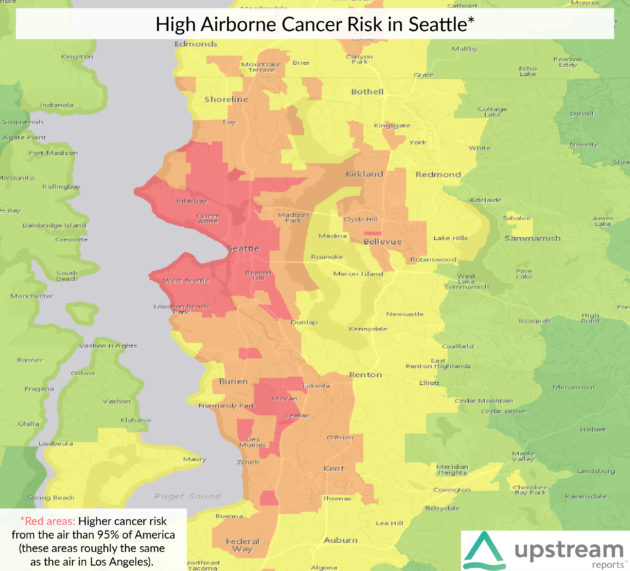
Upstream’s compiled data shows that “Seattle’s air is demonstrably and measurably worse than New York or Los Angeles,” said Bedbury, who now serves as Upstream’s CEO.
He said Seattle’s air contains “exotic heavy metals and carcinogens” that come from industrial and transportation hubs, and soil and water can be contaminated by local superfund sites — polluted spots that are monitored and cleaned up by the EPA. There are four superfund sites in Seattle, according to the EPA’s website.

Those are the kinds of insights Upstream Research wants to bring to light. The company was founded two years ago by Bedbury and several others, including his father Scott Bedbury. While some founders have moved on, the startup now employs nine in its headquarters on Bainbridge Island, Wash., and a satellite office in Bend, Ore.
It also has deep roots in Seattle’s scientific community, and is advised by the likes of Lee Huntsman, president emeritus of the University of Washington and a major figure in Seattle’s biotechnology industry.
Upstream’s mission almost reads like an environmentalist take on Robin Hood. Its goal is to bring together troves of government data, like that on superfund sites, to help organizations and individuals understand health risks that come from their environment.
Bedbury said data on environmental health risks is often hard to understand and lies scattered throughout different government entities.
“There’s a bunch of different ways to tackle these problems, and sometimes putting it on a map or putting it in space opens up new connections you wouldn’t normally see,” he said.
“The near-term goal for us, that I think is attainable, is to put the data in one place — put everything we can find from the federal government, and even states, counties and cities, into a place where they are searchable by the same spatial location,” Bedbury said.
The startup is working to integrate data like the risk of lead exposure, how toxins move through the air and water, and even data from health organizations on the relative rates of certain diseases across the country.

Bedbury emphasized that Upstream doesn’t attempt to make correlations or predictions based on this data. Just because an area has a high risk of lead exposure doesn’t mean there’s lead in the water, he said — it just means that area might need a checkup more often than one with a lower risk.
The underlying principle is that of free access to information.
“This data needs to be put together in a responsible manner and made available,” Bedbury said. “I believe that it continuing to not be available easily only benefits a certain group of people.”
Insurance adjustors or those involved with chemical and industrial plants might be able to root out the data, he said, but without a service like Upstream a layperson might never know it exists.
Upstream will use the data to fuel two products: the Upstream Navigator, an application that presents all of Upstream’s data, which will be made available to nonprofits and academics; and Upstream Reports, condensed summaries of data specific to one address which can be ordered by anyone.
Upstream Reports launched for a beta test last week, and customers can get their first report for free, and following reports for $5 each.
The startup is also embarking on its own research projects as part of their launch. Bedbury said they used the Navigator application to analyze every school in the U.S. for risks of toxins and other environmental health factors. They were surprised to see that nine of the 100 schools most at risk were in King County, he said, many of them in Seattle itself.


