Even after death, the philanthropic initiatives from Microsoft co-founder Paul Allen just keep on coming.
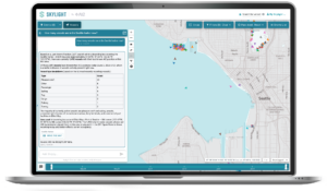
Today the Paul G. Allen Philanthropies and its consortium of partners unveiled the Allen Coral Atlas, a database of satellite imagery and environmental data aimed at mapping and monitoring the world’s coral reefs in unprecedented detail.
The foundation of the atlas is a global mosaic of satellite imagery, acquired starting last year by Planet’s constellation of Earth-imaging satellites. The images document coral reefs at a resolution of 4 meters (13 feet) per pixel.
Other partners — including the University of Queensland, the Carnegie Institute for Science, the Hawaii Institute of Marine Biology and the National Geographic Society — are analyzing and validating the images to produce maps that show reef depth and water color, and discriminate between the reefs and algae, land, rock, sand and rubble.
“Paul challenged us with a bold and audacious goal — save coral reefs around the world,” Bill Hilf, CEO of the late billionaire’s Vulcan Inc., said in a news release. “The Allen Coral Atlas is our first step toward fulfilling that mission.”
https://www.youtube.com/watch?v=gnYK4d1Z3jM
Reef ecosystems provide protection for thousands of species of fish and plant life, and serve as world-class tourist attractions. But they’re facing threats from climate change impacts such as warming ocean temperatures, as well as pollution and destructive fishing practices. Recent studies suggest that a quarter of the world’s coral reefs are damaged beyond repair, and another two-thirds of them are under serious threat.
The atlas’ first detailed geomorphic and benthic maps focus on Mo’orea in French Polynesia, Lighthouse Reef in Belize, West Hawaii Island, Karimunjawa in Indonesia, and Heron Island on Australia’s Great Barrier Reef. And there’s much, much more to come.
The Allen Coral Atlas will be updated with follow-up satellite imagery to track how the world’s coral reefs are responding to environmental changes. “Seeing change is the first step to making change,” said Andrew Zolli, vice president of global impact initiatives at Planet.

Sophisticated software will help conservationists and policymakers plan their next steps.
“We’re developing novel algorithms and applying them to Planet’s satellite data to detect and analyze changes in reef cover and condition,” said Greg Asner, staff scientist for the Carnegie Institution for Science. “Over time, we’ll be able to determine which reefs are bleaching and where, giving decision-makers and the reef management community critically important information needed for response and conservation.”
Allen, who passed away two weeks ago at the age of 65 due to non-Hodgkin’s lymphoma, left a rich legacy of science projects ranging from the Allen Institute for Brain Science to the Great Elephant Census. He was a vocal advocate for open science, and in line with that stance, the Allen Coral Atlas will be freely licensed for non-commercial scientific and conservation uses.
For more about the atlas, check out this report from National Geographic and this feature from Vulcan.