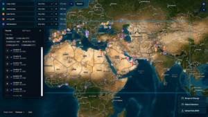
Seattle-based Spaceflight Industries is giving early adopters a preview of its online BlackSky satellite imagery platform, which blends overhead views of sites around the world with social-media posts and other reports about what’s shown in the pictures.
One of the first subjects to be tackled is the humanitarian crisis in the Syrian city of Aleppo, where tens of thousands of civilians have been caught in devastating bombing attacks and house-to-house fighting. That’s apt, because the members of the early adopter program include the United Nations as well as the World Bank and RS Metrics, a company that uses satellite imagery to track global developments.
“Tracking critical global events as they happen is of interest to all of our early customers,” Jodi Sorenson, vice president of marketing and communications at Spaceflight Industries, told GeekWire in an emailed comment. “We chose to use Aleppo as an example to demonstrate the platform’s ability to provide insights on areas of particular international importance.”
The BlackSky platform offers access to imagery from more than 10 Earth-watching satellites, including Korea’s KOMPSAT spacecraft and UrtheCast’s Deimos-2. Customers can also use the platform to order up near-real-time images of specified sites.
As BlackSky builds up its own 60-satellite constellation, pictures from those spacecraft will be put online as well. The first BlackSky satellite, a prototype called Pathfinder-1, was launched this year in preparation for the start of commercial space operations in 2017. The full constellation is due to be in orbit by 2020.
The platform offers much more than raw imagery: It uses curated data feeds as well as machine-learning tools to link up the pictures with news reports, social-media posts and other information about the locations shown. Users can also scan through satellite data and additional context based on specified themes, such as geopolitical conflicts, disease outbreaks or energy resources.
“Our business plan has always been to look at the planet in real time, in every spectrum, to solve real-world problems,” Spaceflight Industries CEO Jason Andrews said in a news release. “Today we are announcing significant progress on that journey. For the first time, organizations can fuse satellite imagery with a wide array of data services contextualized in time and space to better understand the most critical issues of our time.”
Rakesh Narasimhan, executive vice president at BlackSky, said the platform could be used to direct humanitarian relief, secure borders, track economic assets or monitor maritime activity, among other applications. Availability will be expanded beyond the Early Adopter Program as BlackSky, a service subsidiary of Spaceflight Industries, develops the program further.
“Having the support of these high-caliber partners and customers at this early stage is very encouraging, and we intend to use their feedback to ensure the platform is poised to provide actionable and tangible value to our global society,” Narasimhan said.
Other companies are also getting a foothold in the expanding market for satellite imaging: Just last week, San Francisco-based Planet opened an office in Bellevue, Wash., which will focus on the development of its satellite data platform. And Planetary Resources, based in Redmond, Wash., is working on its Ceres satellite constellation for hyperspectral Earth imaging.