Seattle-based Spaceflight Industries is sharing some of the first pictures of Earth ever taken by its low-cost, high-resolution BlackSky Pathfinder-1 satellite – and they’re spectacular.
The roughly 100-pound (50-kilogram) Pathfinder-1 spacecraft was launched from India’s Satish Dhawan Space Center on Sept. 26 as a ride-share payload on a PSLV-C35 rocket. Spaceflight Industries says the satellite cost $10 million to build and launch, which is relatively cheap for orbital imaging capability.
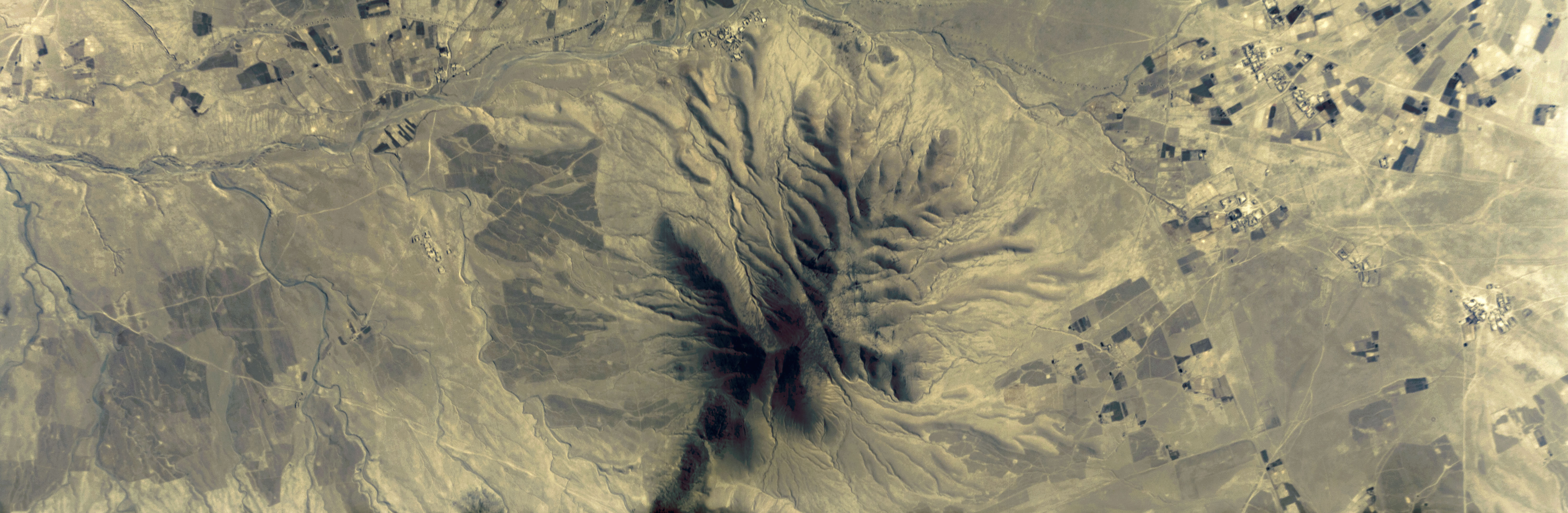
The Pathfinder-1 images released today confirm that the BlackSky concept works. The pictures provide breathtaking views of farms and industrial sites near Beijing, the suburbs surrounding Tokyo, and mountain ranges in China and Afghanistan.
Each image spans an area measuring about 6 miles by 2 miles (10 by 3 kilometers), with a resolution of roughly 6 feet (2 meters) per pixel.
“As we continue to calibrate the system, our images will become even sharper,” Jason Andrews, Spaceflight Industries’ CEO, said today in a blog posting.
This first satellite is orbiting Earth at an altitude of 428 miles (690 kilometers). When BlackSky’s commercial constellation of 60 satellites goes into operation, it’s expected to send back 1-meter-resolution pictures from a height of 280 miles (450 kilometers).
“We have proven out our overall business plan and system architecture, and are on track to revolutionize our understanding of the world,” Andrews said in a news release.
The BlackSky network’s capability is due to double early next year when Pathfinder-2 is launched as a ride-share payload on a SpaceX Falcon 9 rocket.
Spaceflight Industries’ aim is to provide on-demand images that can be delivered in as little as 90 minutes, at a cost of as little as $90 per image.
Andrews has said widespread availability of Earth imagery could revolutionize endeavors including agriculture, urban planning, emergency response, humanitarian relief and environmental monitoring.
“Poking around the planet and looking at whatever you want, when you want, is a powerful thing,” he said today.
Here are a few more pictures from BlackSky Pathfinder-1. Click or tap on each image for a larger, higher-resolution version: