As more and more drones fill the skies, increasingly sophisticated methods will be required to track them under increasingly challenging conditions. How will they navigate if they lose touch with the Global Positioning System? How will authorities know who to call if a drone goes wrong?
Two experiments illustrate how those questions are being addressed. One is being conducted by University of Washington researchers at the Columbia Gorge Regional Airport. The other is being done in cooperation with the Choctaw Nation in Oklahoma.
First, about that GPS issue …
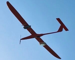
Antenna tracking system for drones
“Right now GPS is the one ring to rule them all: Without it, tiny drones all the way up to commercial aircraft can’t do their jobs. It’s a huge liability,” Christopher Lum, a UW research assistant professor of aeronautics and astronautics and the director of the Autonomous Flight Systems Laboratory, said today in a news release.
Lum and his team have developed a system that’s designed to use a backup navigation technique if GPS satellite links fail. They set up a large ground-based antenna array that can pick up GPS signals from a transponder on a drone, and triangulate on the signals to determine and broadcast the drone’s position.
“We’re just modifying the autopilot onboard the aircraft,” Lum explained. “Instead of using GPS information to navigate, it’s listening to this message coming from the ground to figure out where it is.”
The antenna array was put to the test on June 12 at the Columbia Gorge Regional Airport, which is on the Washington state side of the Columbia River near The Dalles, Ore. A test drone successfully made its way along a 1.25-mile flight path without the use of GPS, with only one deviation that was due to strong winds.
The team’s next step is to work with T-Mobile to tweak the navigation system so that it works with cellphone towers.
“T-Mobile has got that black magic to know where a phone is located anywhere within their antenna array,” Lum said. “So instead of being stuck in the Columbia Gorge region, our drones could use the cell network to get that location information anywhere there is cell coverage. It’s beautiful.”
Eventually, the team aims to incorporate the navigation system into a drone network to transport medical supplies around rural areas of Washington state.
Built-in ID system for drones

Meanwhile, in rural Oklahoma, the Choctaw Nation and its partners have just demonstrated how drones can be used to look for lost cattle, monitor wildlife, lay down bait for wild pigs and take on other agricultural tasks.
“We see drones as an extension of smart farming technology. Drones provide that next step toward robotics and automation,” USA Today quoted Mike Komp, an agricultural drone expert at Oklahoma’s Noble Research Institute, as saying.
Oklahoma’s project is one of 10 experiments approved earlier this year by the U.S. Department of Transportation to expand the frontiers for drone operations.
The Oklahoma experiment is testing Intel’s Falcon 8+ drone, which is equipped with thermal sensors for nighttime operations. It’s also testing a Bluetooth-enabled identification system known as Open Drone ID. The beacon-based, wireless system makes it possible to identify drones whenever they’re in range of a receiver, such as an app-equipped smartphone.
Intel is leading the workgroup that’s developing Open Drone ID to become an ASTM-approved, open-source global standard. If it’s implemented, every drone will broadcast a unique ID as well as its location, direction, altitude, speed, model, base location and other data.
The technology would address one of the big issues currently surrounding drone operations: how to determine who’s responsible for wayward drones. The FAA already has a drone registration system in place, but having the ID system built into the drones themselves would ensure compliance.