There’s new cause for hope in the fight against wildfires, and it involves Insitu, a Boeing subsidiary that’s headquartered in Bingen, Wash., and specializes in unmanned aerial vehicles.
Today Insitu announced a partnership with FireWhat, a California-based company that focuses on monitoring natural resources with Geographic Information Systems; and Esri, the global market leader in GIS software.
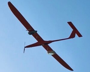
The three companies will use Insitu’s ScanEagle drones, FireWhat’s fire-monitoring technology and Esri’s ArcGIS platform to provide near-real time, web-based video feeds to mobile command centers.
During the day, military-grade electro-optical cameras will help fire incident commanders monitor the battle against wildfires. During the night, infrared cameras will keep watch. The aerial reconnaissance system will make use of an integrated imaging system developed by Insitu’s INEXA Solutions.
“This is a revolutionary breakthrough in firefighting, as the typical 12-to-24 hours of critical information lag time during darkness or in smoky conditions is eliminated,” Jon Damush, vice president and general manager of Insitu Commercial, said in a news release.
FireWhat CEO Sam Lanier said “partnering with Insitu will allow all of us to continue developing advanced technologies that can be deployed globally to effectively and intelligently fight wildfires.”
The partnership is particularly timely for this summer, when large wildfires are raging over hundreds of thousands of acres of land from Arizona to British Columbia, and from Washington and California to Montana and Wyoming.
Smoke from the fires could cast a pall over Western observations of the total solar eclipse on Aug. 21.