The Northwest’s largest earthquake since 2004 shook up the region Tuesday evening as a magnitude 4.8 quake hit 11 miles northeast of Victoria, British Columbia.
At 11:39 p.m. PT on Tuesday, the earthquake struck 85 miles northwest of Seattle at a depth of 30 miles. KOMO reported that several residents of Washington towns like Port Angeles and Anacortes felt substantial shaking, in addition to folks around Vancouver and Seattle.
https://twitter.com/60Blues/status/682106867019984896
https://twitter.com/jimmylovaas/status/682104313485737985
Officials in Canada and Vancouver, B.C., are reporting no known significant damage. The National Weather Service in Seattle said there is no tsunami danger.
According to the Pacific Northwest Seismic Network, this is the largest earthquake in the Northwest region since a magnitude 4.9 quake in 2004 that hit near Newport, Oregon. There have been nine quakes with a magnitude higher than 4.9 since 1995, including a 6.8 ripple near Olympia, Wash. in 2001 that caused $2 billion worth of damage to the state and injured hundreds.
There was also a separate magnitude 4.4 earthquake on Sunday near San Bernardino, Calif.
Tuesday’s quake certainly wasn’t the “Really Big One” — a massive 9.0 earthquake that the New Yorker predicts has a one-in-ten chance of hitting the region in the next 50 years.
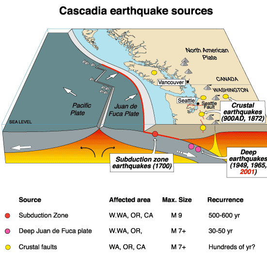
Still, though, this is the largest quake in more than a decade. It’s another reminder of the potential for the Cascadia Subduction Zone to unleash a huge quake off the coast of Washington and Oregon.
In the meantime, it might be a good idea to get an emergency kit and follow the advice of local disaster experts.
Earlier this week, the Seattle Office of Emergency Management released an interactive map of the area that shows the likelihood of how natural disasters, like earthquakes, will affect your neighborhood.
Separately, the University of Washington and the PNSN are part of a consortium that’s developing and testing an early warning system for the West Coast, along with Caltech, Berkeley, the University of Oregon and the U.S. Geological Survey. Congress recently approved more funding to help build the system, which would be modeled after a similar system already in operation in Japan.
If you felt the earthquake, you can fill out a USGS report here. And here are some good tips to prepare for an earthquake: